
Burke, Idaho is a little mining community. You take the East Wallace exit (62) turn North and follow the sign to "Burke". Go about eight miles up the winding road to the power sub-station, which is the unloading area. It's nice and wide and will accommodate even large trailers. You will pass by several little "towns", such as Gem, Black Bear and Yellow Dog, just to name a few. They are not really "towns"; more like groups of houses. From the parking lot there's about 3 directions to go. By the fence and East is the way to the two lakes, which you have to "find" the trail to the second one, going up through the trees. Along the way there's some nice little climbing along the power lines. If you go on the trail to the lowest part of the parking lot, is the way to some side hills and ridges to the west. If you go on the most upper trail from the parking lot is a mixture of trails (with several dead-ends), trees and lots boondocking in the trees. This is the one fantastic feature of this area; the boondocking goes a long way, with several miles of it. You have to know the right routes, so a guide is recommended. There is a sign requiring a trail pass (separate from an Idaho registration), but it's unknown if this is enforced. There has been some evidence of one of the trails being groomed.
Here's more details about the area, and trails, etc.


Burke is a ghost town in Burke-Canyon in Shoshone County, Idaho. Once a thriving silver and lead town, it is now far smaller than at its height. In 2002, about 300 people lived in or nearby Burke Canyon. It was situated in a canyon only about 300 feet (91 m) wide, located on Burke-Canyon Creek Road in the northernmost part of the county. It was the home of the Hercules silver mine, the owners of which were implicated in the Idaho mining wars of 1899. The road is normally maintained, which is surprising for this area, which is poor and rough.


 Riders typically meet in the morning in Cour' D Alene at Tesoro Gas Station and deli at the East end of Cour 'D Alene, Idaho.
Even though there's folks in and out between 6am and 10 am, The normal group (by default) leaves at 8am.
Riders typically meet in the morning in Cour' D Alene at Tesoro Gas Station and deli at the East end of Cour 'D Alene, Idaho.
Even though there's folks in and out between 6am and 10 am, The normal group (by default) leaves at 8am.
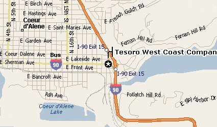
There are several Cour 'D Alene exits. Going east on I-90, the last two East exits are a little confusing at first. The first one says "15th street" (exit 14, I think) and the last one says "Sherman/Fernan" which is exit 15. Take this last one (exit 15). The hyway sign "food, gas", etc. will be obvious for that exit. Go down to the light; the gas station will be there. Also this street is the way to Fernan, which is a nice trail riding area, but that's about it. This map might help.
Their address is;
Tesoro 2-Go #62133
E. 2301 Sherman
Coeur 'D Alene, ID, 83814
(208) 667-0538
![[Kar's sled page]](images/winter_home3.gif)